Complete Streets is finally law: this is how we won.

Complete Streets manual.jpeg

Ten years ago, Complete Streets was an empty promise on a sheet of paper. Citizens across the city lacked access to reliable and safe transportation. Poor road construction led to numerous bike injuries. Cyclists and pedestrians alike were vulnerable and unprotected. And these issues considerably worsened in formerly red-lined communities of color. 

We knew that if we wanted a better city for bicycling, we needed to strengthen Complete Streets. So that’s what we began working on: in 2016, we partnered with Councilman Ryan Dorsey to create an equity-oriented, safer, and more efficient piece of legislation. 

 This led to one of Baltimore City’s largest re-write of city laws ever. We started by completely changing the hierarchy of the street, placing pedestrians, cyclists, and public transit before cars. This eventually became the Complete Streets manual, a legal street design document that places safety and equity first. Yesterday, the manual was finally adopted as law under Mayor Scott’s leadership. 

This manual, developed by Graham Young in Baltimore City Department of Transportation alongside transportation consultants and using the guidance of the National Association of City Transportation Officials is one of the most progressive Complete Streets documents in the country.

Complete Streets was a huge overhaul, and we didn’t do alone. Residents spoke up and shared how safe and accessible stress were crucial to their neighborhoods. A massive coalition of other organizations helped us reach out to new neighborhoods and gather more support. And most importantly, Bikemore supporters like you helped to fund the entire journey.

We wanted to share this story with you, because we would not have won Complete Streets without you. All of our work coalition building, lobbying, strategizing with legislators through our 501(c)4) was completely and only funded by individual supporters like you. Your support has led to protected bike lanes, new bike trails, dedicated transit lanes, and demanded citywide improvements that benefit everyone in Baltimore. You are the author of this story. 

Without your support, we would have no victory story to tell. 

Can you help us keep pushing for change?

Start a recurring donation to Bikemore in Action today.

Policy Q&A with Jed: Recap

Selfie of Jed on a bike ride in Memphis.

The past two weeks, our Policy Director Jed answered your questions on Instagram. In case you missed it, here’s a recap of the Q&A. We’ll be hosting these Q&A sessions every other week, so you can join us to ask your policy questions on Instagram next on March 2-3!

What’s stopping us from stenciling look out for cyclists and other visibility stencils on streets and sidewalks?

Nothing! The Department of Transportation has a Right-of-Way Community Art program that you can apply for, but examples of unpermitted DIY stencils are all over Baltimore. (Like all of the trail markers!)

Rate the maglev on a scale of one to ten.

One is the worst right? One. But seriously, fix what we have first. (Read more on my twitter).

Explain the City’s process of evaluating removal of parking lanes for bike lanes.

The new Complete Streets manual ranks the overall roadway priorities as follows: 1) Walking, 2) Cycling/Public Transit/Micromobility, 3) Taxi/Commercial Transit/Shared vehicles, 4) Single occupant automobiles. It also creates ranked priorities of street zones based on land use/road typology. The full rationale is explained in the manual, which you can read here.

What are some advocacy materials for bike lanes on major arterials? Safe, direct routes even if it’s not cheap or easy!

We advocated for the adoption of the Baltimore City Separated Lane Network Plan in 2015. It measured traffic stress levels of city streets to make a base map of where protected lanes were needed on arterials or elsewhere. From ti we got a “skeleton” fo separated lanes that would connect 85% of Baltimore neighborhoods.

The whole thing — connecting 85% of Baltimore neighborhoods to high quality bike facilities — would cost less than we usually spend on a single road project. We want it built.

What is a “high quality bike facility”?

Something that people ages 8 to 80 feel safe riding on. Or in other words, something people of all ages and abilities will use.

What are some of Bikemore’s policy and project priorities of 2021?

Reduce or eliminate car parking requirements that make housing unaffordable. Allow denser housing so people can more easily access opportunity. Get city employees transit passes or let them take cash in their paycheck instead of a parking subsidy. Pass the transit safety & investment act in Annapolis, fully funding repairs to our failing MTA system. 40% of MTA riders are essential workers, nearly the highest % in the country. Our essential workers and all transit riders deserve a safe and reliable system.

Advocate for the design and construction of the Greenway Trails Network and the Separated Lane Network

What happened to all the Slow Streets signs?

The City has removed the barriers during program evaluation, in part because they were poorly designed and easy to destroy. The City has allocated funding to buy more substantial/durable barriers for the Spring. The evaluation will focus in part on building community support to reduce vandalism.

What are some of the biggest lobbying priorities that Baltimore residents can engage with right now?

Tell Senator President Ferguson and your State Senator and Delegates to support eh Transit Safety & Investment Act. You can do so here:

Support legislation that increase density and housing affordability by allowing apartment conversions and undoes policies routed in explicit racism and anti-renter sentiment.

How can we streamline the process of building on-road facilities corresponding to the new portion of the Jones Falls Trail to Mt. Washington?

We’re working with the East Coast Greenway on ideas for connections on street in Mt. Washington. Before the Complete Streets law existed, community members fought building separated lanes on Kelly Ave. The law would prevent that. But only when a new project/resurfacing comes up.

Lake Montebello has been an absolute delight without cars. Can/will it say that way forever?

Yes it can! Both are supportive of keeping the closure.

What are the most immediate improvement we sill start seeing as a result of Complete Streets?

Already we’ve seen:

  • President St. lane upgrade with flex posts

  • Greenspring Ave upgrade with flex posts

  • Better crosswalks by default

Soon:

  • trail or protected bike lanes on Patapsco Ave.

  • Safe crossing of Hanover Street bridge

What will Complete Streets make possible in Baltimore that wasn’t before?

A ton. Everything in this manual is now enforceable by law. Before it was enforceable by whomever yelled the loudest. Here’s an example: specific guidelines for bike facility selection we now must follow (see page ___). Legally enforceable, data-driven guidance.

Can we be optimistic that the pace of street redesigns will pick up in the next few years?

Definitely, it’s a priority of Mayor Scott. DOT has allocated real money to vision zero and quick builds to improve safety. And now it’s the law.

Any updates on the Big Jump?

City evaluation report is due soon. City says it shows much higher usage than parallel routes and has no impact to travel times for cars. A total redesign plan is coming, and the barriers will be upgraded to concrete mid-term when digging in the road is done.

Is there hope for a more bike-friendly 33rd St.?

Yes! DOT has a grant to begin design on two Olmsted Parkways (33rd St. and Gwynns Falls Parkway) this year!. The Olmsted Parkways were intended to connect people to nature and parks by all modes of transport. Median Pathways and wide sidewalks were standard since most people din’t drive at the time.

Baltimore’s Olmsted Parkways plan came to fruition at the peak of early automobile growth. Grand designs were scaled back tot he corridors we see today. But historic documents can show us the Olmsted intent. And like the firm’s other projects nationwide, they were “complete streets.” The Gwynns Falls Parkway plan included a median trail for walkers, bikers, and people on horseback to safely travel from Leakin Park to Druid Hill Park.

On 33rd St., property owners demanded a scaled back plan from the original grand vision. On a field visit, Olmsted architect PR Jones scaled back the original plan. But even in the scaled back version, his field sketch included a trail through the center of a 40 ft median.

The goal of DOT design work will be to build a full 35-mile trail loop, connecting our major parks like the original Olmsted vision. 33rd is a key component. The trail didn’t get installed 100 years ago, but we can fix that now.

What’s the potential for better snow removal on trails? Bike lanes have been pretty good this year.

We have the technology available! But a lot of the trails are Rec and Parks responsibility, and they have severe resource constraints. We’re advocating DOT take on more trail clearance

What can be done about all the vehicles parking in the Maryland Ave bike lane?

Enforcement has been pretty spotty because of COVID. 311 every incident you see.

How can I get involved in bike advocacy?

Keep following us and sign up for emails on bikemore.net! We post asks regularly and will have events to gather when it’s safe.

Dockless Vehicle 2020 Update

Screen Shot 2021-02-03 at 1.50.14 PM.png

Bikemore has supported the City’s Dockless Vehicle Program permit for e-scooters and bikes since before the pilot launched in 2018, writing the white paper that served as the basis for the pilot and supporting legislation to make the program permanent. 

While this year’s permit cycle was meant to end in August 2020, it has been on hold due to Maryland’s State of Emergency. So how has the scooter program been doing during pandemic times? 

Here are the highlights from the Department of Transportation’s latest update:

  • Vehicle trips in 2020 decreased 55.6% from 2019. We also saw a shift from weekday rush-hour commute trips to midday/weekend usage. 

  • Trips around the Inner Harbor, downtown, and at college/university campuses dropped significantly, while trips around parks and along transit corridors increased. 

  • DOT used Dockless Vehicle Permit funds to perform an audit on bike facilities and completed work orders to replace 100 flex posts, convert two storm drains to be bicycle/scooter friendly, and added green paint to improve visibility at intersections.

  • DOT is currently working on installing over twenty bike/scooter parking corrals around the city, prioritizing transit connections, reducing vandalism, and equity zones.

  • After the State of Emergency is lifted, DOT will release an updated Rules and Regulations for the Dockless Vehicle permit for public comment before vendor applications open.

  • Currently, SPIN and Lime are the only two dockless vehicle vendors in the city after Lime acquired JUMP and Bolt failed to meet permit requirements.

  • Lime has re-launched JUMP bikes in the city, but the fleet is still quite small.

Also, Lime chose Bikemore as their “Lime Hero” partner back in September 2020! Riders can round up their rides to make a small donation to Bikemore and have the opportunity to learn about our work through the app.

Read the full memo from DOT here.

Cycling Q&A Recap: Winter Riding Tips!

190825 Bikemore at ATA 2019 Youth Jam 09.jpg

Our Programs Coordinator, Menelik, hosted his first live Q&A session on Instagram last Thursday. He answered a few questions about winter riding - check it out!

And be sure to join us for future Q&A sessions if you have questions about cycling, buying the right bike for you, bike maintenance, and more! Q&A sessions will be hosted every Wednesday from 12-1pm over Instagram.

What’s the best way to carry a bike up and down the stairs?

One way is with one hand on the top tube and the other on the handlebars, and then lifting the bikes top tup above the shoulder. Another way to simply grab the top tube and handlebars in one hand and lift off the ground - this works better with lighter bikes.

What’s the best way to clean winter grit/salt out of my drivetrain?

First, let’s consider a common mistake of having too much lubricant on the chain, which attracts dirt and excess debris. That aside, here’s a suggested step-by-step process:

  1. Preferably remove the rear wheel and install a “dummy hub” (Park Tool has one).

  2. Use a stiff brush and apply degreaser to scrub jockey wheels (where applicable), sprocket, and chain below the chain stays to prevent gunk from entering the bottom bracket area.

  3. Using a different, clean brush, apply soapy (e.g. dish liquid) water scrub and repeat step 2.

  4. With steamy, hot water inside a spare water bottle (don’t use this for drinking!), rinse away the soapy water as a light rain would.

  5. While turning the cranks, use a cotton shop towel to dry. Or you can also air dry.

  6. Link by link, apply lubricant. After you’ve lubed the entire chain, go back and wipe off the excess with the cotton shop towel.

  7. The rear cassette and cog can be handled separately by degreasing and scrubbing.

Do you have a recommendation for eye protection that won’t fog?

When wearing a mask or face covering, it helps to bring the material above the nose and under the glasses. There is also defogger spray that can be applied to lenses.

Who has good winter biking apparel?

Try out outdoor supply stores. Locally, you can go to H&H Outdoors (in Lauraville) or REI (there are a few locations in the DMV area).

What kind of gloves should I get to ride in the winter?

There are many different types, so depending on what you’re comfortable with, the answer will change. Camping and outdoors stores have great gloves for biking. Another tip you might try out is to put a couple dashes of cayenne inside gloves and socks for extra warmth!

Harford Road Bridge Redesigned with Complete Streets Principles

Last Thursday night, Baltimore City Department of Transportation hosted a meeting with eighty community members in attendance to provide an update on the proposed design changes to the Harford Road Bridge. 

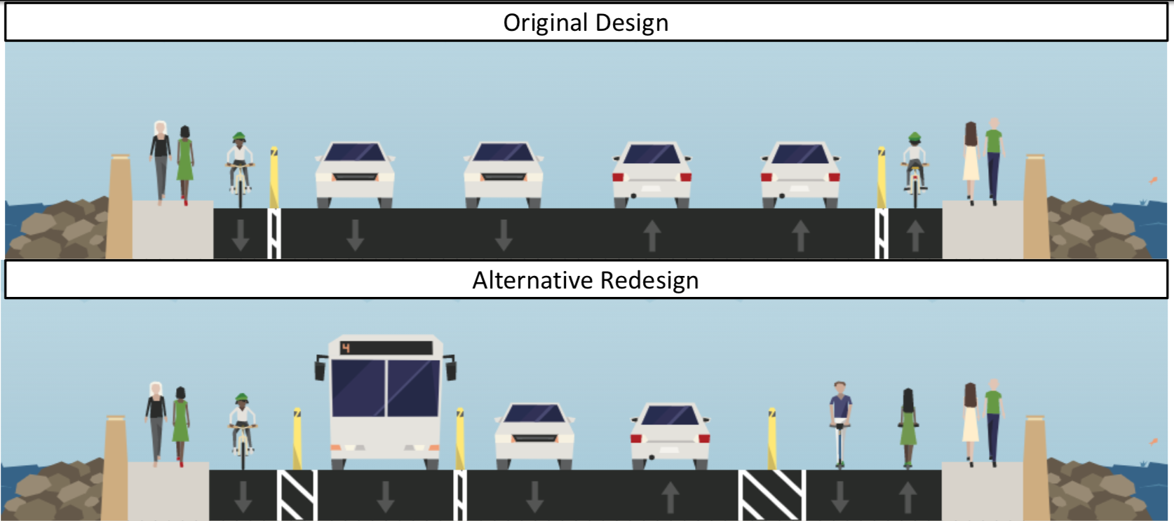
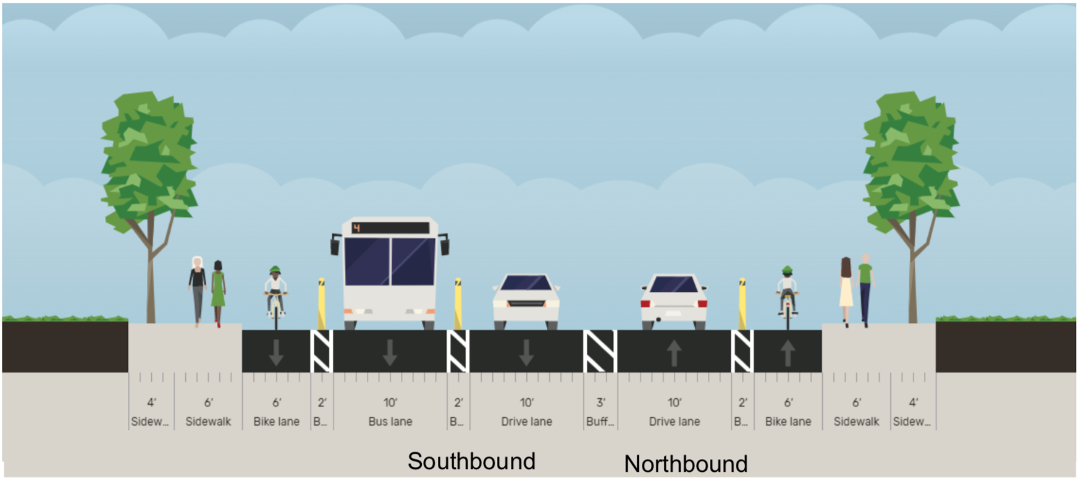
The newly proposed design reduces four lanes of car traffic to two, and reallocates this space to a southbound bus travel lane, additional lanes for mixed-use walking and biking, and more buffer between moving traffic and pedestrians. Complete Streets Manager Graham Young cited the newly adopted Complete Streets Manual and Separated Lane Network Plan as guiding documents for the new design.

The design also extends changes on Harford Road to the north and south of the bridge, reconfiguring dangerous intersections and extending separated bike lanes that make both people biking and walking on the adjacent sidewalks safer from passing cars.

Overall, folks on the call were excited about the new design and also advocated to keep Lake Montebello closed to cars and for additional closure of Walther Avenue between Harford Road and Argonne Drive.

We encourage you to view the presentation and leave comments on the proposed design here, or email dot-community@baltimorecity.gov with your comments. 

Since the Harford Road bridge has been closed, the streets to the north and south have seen less traffic and have been adjusted to accommodate space for other uses, like added parking, outdoor cafes, curb extensions, and separated bike lanes. These were long-standing community goals that existed well before the bridge project began design and construction. 

It never made sense to have a bridge design with 4 lanes of high speed car traffic and narrow, unprotected bike lanes. But that’s what the original design called for. 

From the first community meeting about the bridge, Bikemore called for a road diet and addition of separated bike lanes to the project. Neighbors complained about the high level of speeds along the current bridge, and were nervous to see the existing guardrails on the old bridge removed in the new design, because they provided basic protection to people walking across the bridge next to highway speed traffic. We were joined in calls for a re-design by then-candidate for 3rd District City Council -- Ryan Dorsey, who made changes to the bridge design a major focus of his campaign.

Despite Dorsey’s victory in the election, along with broad community support for design changes and Bikemore’s advocacy, no substantial changes were made from the original bridge design presented. In 2018, the bridge project moved to construction. As reported at the time in the Baltimore Sun:

City Councilman Ryan Dorsey, who represents the area and runs a Facebook page dedicated to news about the bridge, criticized the new bridge’s design as “incredibly unsafe” because the bike lane is not physically separated by barriers from the road, he said.

If it had been designed in Montgomery County, Dorsey said, a separated bike lane would be required due to traffic volumes and observed speeds.

“It’s really a failing of DOT that a safer design was not planned from the outset, even worse that safer design was called for by community members from the earliest stages, but DOT insisted on this unsafe design,” Dorsey said. “This DOT has not really inspired much confidence so far, but I’m still holding out hope that a change will be made before we get to a point where it’s really too late.”

Over the past 15 years, the city transportation department has ignored calls from residents, advocates and public officials to build a new bridge that is safe and accessible for pedestrians and bicyclists, said Jed Weeks, policy director of Bikemore, a bicycle advocacy group.

“Instead, they've doomed generations of Baltimoreans to an unsafe design with minimum width sidewalks and unprotected bike lanes next to speeding traffic,” Weeks said in a statement. “This bridge is a total failure in planning and an example of why we had to pass an ordinance to force BCDOT to do better in the future."

While the beginning of construction marked the end of advocacy for a smaller bridge design that could have saved millions of dollars in construction costs, we continued to advocate for an improved reconfiguration of the wide bridge that was to be built. In that time, we gained new leadership in the mayor’s office, new leadership at BCDOT, and Councilman Dorsey was re-elected, cementing that there is broad support for his complete streets vision within the 3rd District.

This redesign, combined with the closure of Lake Montebello to car traffic, the coming design and installation of trail along St. Lo Drive and 33rd Street, and future expanded separated bike lanes along Harford Road are a culmination of years of advocacy that would not have been possible without Bikemore’s supporters.