Bike Lanes

Mount Royal Ave Cycle Track Update

Last night, the engineering firm tasked with developing the Midtown / Mount Royal Streetscape project revealed 95% design plans at a community meeting hosted by Baltimore City Department of Transportation. 

This project has been in the works for four years, and the last project meeting was hosted in 2014. In fact, Bikemore's first major advocacy push as an organization was back in 2012, for inclusion of bike facilities in this project.

In January 2016, we provided a detailed overview of this project, and stated that "red-lined" design changes (changes added once construction has begun) are critical to making this a safe and worthwhile project.

None of these major recommendations have made it into the project, nor have the recommendations of other key stakeholders and community members.

We need to reconfigure the I-83 off-ramp.

A reconfiguration of the I-83 offramp onto Mount Royal Avenue must be considered. Currently, the design asks bicyclists and pedestrians to cross a highway offramp that will only be signaled with a flashing yellow warning beacon. This highway offramp was never intended to be permanent, and it should be closed as a part of this project. At minimum, the offramp needs to be reconfigured where it interacts with the cycle track. 

1) Present 2) Ramp Closure 3) Reconfigure Ramp

We need to extend the project up to North and down to Guilford.

The protected bike lane currently ends several blocks short of North Avenue. This will provide an incomplete connection to the lanes we are advocating for in North Avenue Rising. The protected lane also currently ends just before Saint Paul Street, and should be extended fully to connect to the protected facility and lanes at Guilford and Fallsway. Federal dollars cannot easily be used to fund an adjacent facility to the Jones Falls Trail, so the city should step in with the red lined extra work funds to extend the facility here.

Connections to Maryland and Cathedral are not well defined.

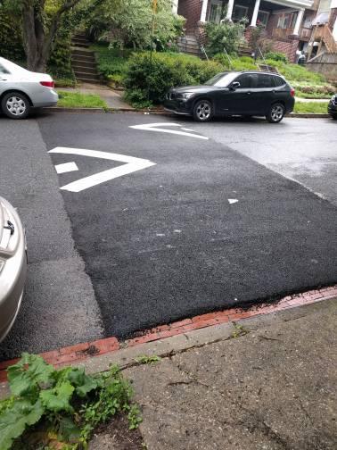
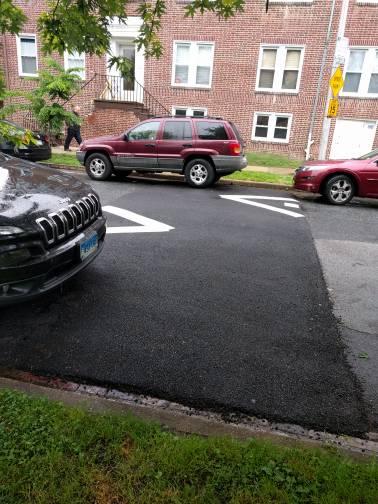
The connection to the Maryland Avenue cycle track is not well defined. We have had instances in Baltimore where two separate engineering firms have worked on two separate projects, and failed to plan for overlap, leading to bump-outs being installed into bicycle facilities. No clear answers have been provided by the engineers about coordination between these projects. 

A bump out installed over a bike lane near Druid Hill Park

A bump out installed over a bike lane near Druid Hill Park

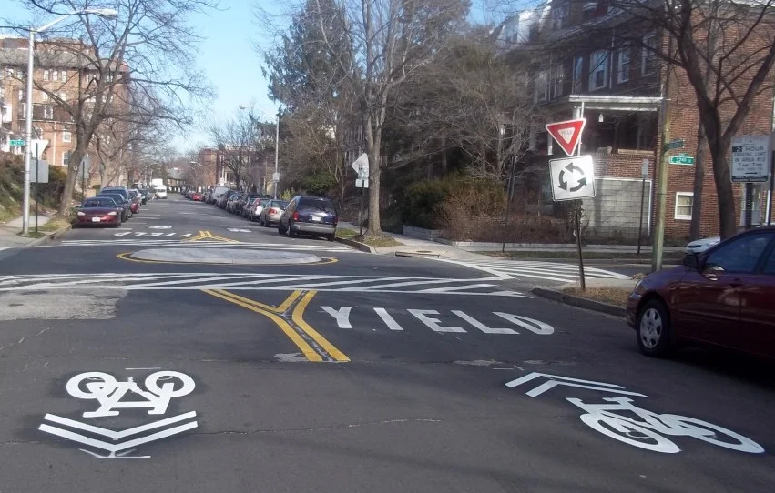
The intersection of the project with Cathedral Street is also concerning. Early project renderings installed a traffic circle that allowed for bicyclists and drivers to better navigate the intersection, but that has since been removed. Bicyclists in the current plans must dismount and cross the street from the protected facility on Mount Royal over a crosswalk to Cathedral.

Confusing intersection at Cathedral and Mount Royal requiring multiple dismounts

Confusing intersection at Cathedral and Mount Royal requiring multiple dismounts

There's no reason to have two travel lanes on Mount Royal.

The project is cutting down median width, removing parking, and taking sidewalk space to try and accomodate two lanes of travel alongside a protected bicycle facility. This is one of the largest sources of discontent with community members. Removing a vehicular travel lane would allow for parking to be restored where it is currently lost throughout the project, while still retaining a protected bike lane and wider medians. These are wins for everyone.

These fixes are necessary before this project begins construction.

Bikemore will work with neighborhood organizations, Councilman Costello, and stakeholder institutions to advocate for these changes to be red-lined into this project so construction is not significantly delayed.

It is frustrating to see a flawed project brought to the table when feedback that could have made this project great was submitted over the past four years.

This is the challenge with projects in Baltimore taking so long to come to fruition--design standards for livable cities are constantly changing. We have a far more progressive DOT than we did four years ago. See the pop-up cycle track announced today on East Pratt as an example. However, when projects like the Midtown / Mount Royal streetscape take half a decade to plan, they are unable to meet the demands of an evolving city.

We will keep you posted on ways to vocalize improvements to this facility, and your support of Bikemore enables us to continue to advocate on your behalf.


Pop-Up Cycle Track on East Pratt Street

DOT is installing a "Pop-Up" cycle track this Thursday!

This Thursday, August 4th, Baltimore City Department of Transportation will be installing a pop-up cycle track on East Pratt Street between South Central Avenue and South Broadway Street. This two-way protected bike lane will remain in place through Friday, August 26th. 

Baltimore City Department of Transportation welcomes community members to join them from 8:00-9:00am and from 5:00-6:00pm on Friday, August 5th at the corner of Caroline Street and East Pratt Street to try out the facility and learn more about bicycle projects in Baltimore.

What are pop-up bike facilities?

Pilot projects, such as pop-up protected bike lanes, are becoming increasingly popular in cities. These projects allow agencies to engage with the public--testing what works and what doesn't in an affordable manner before substantial capital investments are made. The conventional project development process proceeds from plan to capital construction over a number of years, while pilot projects only take a few weeks to organize and construct. These projects help communities try new treatments, re-envisioning what their streets and communities can look like without the commitment of a capital project.

Ride it, show support!

Definitely try to stop by in the morning or evening on Friday and check out the installation, and make it a part of your commute if you live in the area. Showing support for this kind of creative testing means we will see it more frequently. And, if you want to ensure that more projects like this turn into full-time bike facilities, donate to Bikemore.

North Avenue Rising: Let's Make it Better!

Baltimore Plans to Improve West North Avenue

This post has been updated to reflect additional information received by Bikemore after publishing.

Earlier this week, Senator Mikulski’s office announced Baltimore’s receipt of a $10,000,000 TIGER Grant for roadway improvements to North Avenue.

The project application, entitled “North Avenue Rising,” was submitted by the Baltimore City Department of Transportation and Maryland Department of Transportation including the Maryland Transit Administration. 

The $10 million in federal funding is being matched by $14.7 million of state funding, $1.6 million in already-committed FHWA funding, and $1 million of Baltimore City funding.

The bulk of the $27.3 million project, $8.9 million, will focus on sidewalk and crosswalk improvements. Investments in transit infrastructure including bus stop shelters, transit signal priority at intersections, investments in the Penn/North Metro Station, and dedicated lanes amount to about $7.5 million. Funding for bicycle infrastructure makes up less than $1 million.

Current Plans Have Flaws

While early in design, the project as currently scoped has major shortcomings. Dedicated bus lanes stop and start through parts of the project, because Baltimore City Department of Transportation does not want to fully prioritize bus service over private automobiles along the corridor. There are bike share stations planned for key intersections, but there are no dedicated bicycle facilities planned for North Avenue in the project. While the dedicated bus lanes will be signed as shared with bikes, other infrastructure is relegated to stretches of parallel facilities that are sometimes several blocks away.

This contradicts the 2015 bicycle master plan, which calls for North Avenue to be a “main route” for bicycles, requiring dedicated, protected bike lanes. It also contradicts a multi-year collaborative community design process undertaken by the Neighborhood Design Center, which culminated in 2015. That plan also calls for protected bicycle facilities along much of West North Avenue.

These improvements alongside dedicated transit lanes would further reduce personal vehicle travel lanes or parking, and Baltimore City Department of Transportation was unwilling at the time of project submission to sacrifice convenience of personal automobile users to accomodate safe, protected lanes for people who bike alongside fully-dedicated transit lanes throughout the corridor.

Through Advocacy, We Can Fix the Flaws

Luckily, it is not too late to improve the North Avenue Rising plan. North Avenue has significant right-of-way, and advocacy for expanded funding of this project and true prioritization of transit and bicycles as required by our complete streets policy, and as outlined in our master plans, could allow for fully-dedicated bus lanes along the corridor adjacent to dedicated bicycle facilities. 

An offset bus lane street (NACTO)

Additional personal vehicle lane reduction or reduction of some parking along North Avenue would allow for design of an Offset Bus Lane Street with dedicated, parking or flex-post protected bicycle lanes. This treatment is endorsed by the National Association of City Transportation Officials (NACTO), of which Baltimore is a founding member.

A median rapid transit corridor (NACTO)

Additional personal vehicle lane reduction or reduction of some parking along with additional funding would allow for a true dedicated Median Rapid Transit Corridor for the widest portions of North Avenue. This treatment would include protected bicycle facilities and a curb-separated right-of-way for transit operations, improving bus speed and reliability while allowing for a future upgrade to rail transit on the North Avenue corridor.

Additional funding should should be leveraged by this grant award to make it a truly great project for Baltimore. The TIGER grant money should not be used for routine resurfacing, instead it should be used to bolster this project's innovation in biking, walking, and transit design. Governor Hogan can pay for the overdue resurfacing of a state marked highway, like he is doing in every other county in Maryland.

Bikemore wants to see North Avenue rising.

>33% of households are zero car in pink areas. >66% of households are zero car in red areas.

Neighborhoods along the project corridor have some of the highest rates of households that lack access to a car in Baltimore City. Dedicated transit lanes will make buses faster, more convenient, and more on-time on this critical transportation corridor. Protected bike lanes will allow people to safely use bike share while calming traffic and making the street safer for people who walk. There is no reason to prioritize personal automobile throughput over the safety and convenience of neighbors and people who walk, bike, and take transit on this corridor.

Agencies involved in this project are open to our recommendations, and we look forward to working with them to advance a vision for North Avenue that truly promotes biking, walking, and taking transit. But more advocacy around complete streets is clearly needed, because a project that does not completely consider and include all modes should not be constructed, and we should not accept a political climate unwilling to include adequate design for biking in project submission.

This is a great opportunity to make one of the only wide roads in Baltimore functional for all users, and a mistake in infrastructure here will have to be endured for years to come. We must get to a place where our city prioritizes people over personal cars by default, not as an afterthought.

As this project continues to develop, we will notify you of ways to get involved and ensure we get the best possible design for people who bike, walk, and ride transit. 

Maryland Avenue Cycle Track Breaks Ground

Construction on the Maryland Avenue cycle track began this morning.

We've been as weary of delays as you, so when the notice to proceed was issued early last week, we kept our fingers crossed and our lips sealed. But it's happening, right now.

You may not see much at first, because preliminary work will focus on ADA compliant sidewalk ramps, roadway patching, and grate replacement. But crews will be working block by block to install the cycle track from 29th Street to Pratt Street for the rest of the summer. 

The city has chosen a reputable contractor with has a strong record of completing projects on time, so we hope to be able to ride a completed cycle track when bike share launches this fall. 

Construction will then continue on the Madison and Monument Street cycle tracks and the Preston and Biddle Street standard bicycle lanes, all of which are a part of this Downtown Bicycle Network project.

The city will be hosting an open house on the project at the Baltimore School for the Arts in August. We will announce that date as soon as it is available. In addition to this public meeting, DOT will be hosting pop-up events to explain the project over the next month. The first pop-up is next Tuesday, July 26th, from 8:00 to 9:00am in front of the Bikemore offices at 2209 Maryland Avenue.

One of the reasons we’ve developed Bikemore’s advocacy arm is to ensure projects like this, that have sat shovel ready for years, are no longer held up by bureaucracy or a minority of noisy NIMBYs. 

Thank you for your patience and faith in our advocacy, and please continue to give generously so that we see more victories like this one, and that we see them faster.

Stop Signs Halt Progress on Guilford Avenue Bike Boulevard

This Saturday Baltimore City DOT will close down 32nd street and Guilford Avenue from 7am to 3pm to remove a debated traffic circle at the busy intersection. Neighbors complained that the small traffic circle did little to slow heavy traffic, and made the intersection unsafe for pedestrians. 

Guilford Avenue received a bike boulevard treatment in 2011. The treatment included traffic circles at various intersections, sharrows, and bike friendly speed humps throughout the avenue from University Parkway to Mt. Royal Avenue. Even in its imperfect state, the low stress route has become a popular and necessary north/south connector for bicyclists, with ridership increasing dramatically on the corridor after installation and growing annually since. There was always talk about adding various improvements, but little was added after the first phase of construction. 

When community meetings were first held in 2010, residents were shown photos of similar traffic calming treatments from around the country. Circles featured vertical treatments like plantings or sculptures. As neighbors began taking ownership of these new public spaces, DOT responded by banning any vertical treatments citing safety issues with emergency vehicles being able to pass through intersections. This policy decision grossly undermined the effectiveness of the circles. 

32nd and Guilford Traffic Circle 

32nd and Guilford Traffic Circle 

A traffic circle in Minneapolis on a similar sized street to Guilford Ave

A traffic circle in Minneapolis on a similar sized street to Guilford Ave

32nd Street leads to a very popular pocket park just East of Guilford Avenue. Pedestrian safety is paramount, as many families in the neighborhood walk through this intersection during the evening rush hour to play in the park. East bound car commuters like to use 32nd Street as a cut-through to avoid waiting on the light cycle at 33rd Street and Greenmount Avenue. 

When several members of the Abell Community Association reached out last summer to get Bikemore's opinion on solutions to the unsafe intersection, we made the following recommendations to DOT: 

  • Remove four parking spots to increase the size of the crosswalks and re-stripe larger crosswalks to improve visibility. 
  • Create vertical elements and reflective signage in the traffic circle so that these visual elements slow traffic. 
  • Create a concrete "channel" or small median leading up to the circle that makes the turning radius narrow and expands the footprint of the circle, again slowing traffic. 
  • Install bike friendly speed humps (humps with small channels for bikes to pass through) leading up to the intersection in all directions. 

Despite DOT staff supporting our recommendations, and working with us to remove the policy that restricted vertical elements in the circle, several neighbors chose to instead advocate for removal of the circle and installation of a four-way stop.

Bikemore attempted to persuade these neighbors to reconsider by offering a small grant to assist with adding plantings to the circle. We have since learned that these neighbors held a meeting in the field last fall with Councilwoman Mary Pat Clarke and Former DOT Director William Johnson, where they demanded removal of the circle and installation of the four-way stop. Councilwoman Clarke was not made aware by these neighbors or Director Johnson that a different treatment was recommended by Bikemore and DOT's traffic and bicycle staff.

While we worked to stay informed about the project through December, communication from DOT eventually dropped off. 

So you can imagine our surprise when a few weeks ago four new stop signs were installed. This countered our recommendations to maintain the spirit of the bike boulevard, while addressing residents' very valid concerns of pedestrian safety and traffic speeds. Furthermore, not being able to review plans and weigh in on changes to one of the city's only decent bike facilities felt like a slap in the face--especially when the direction of this project could have been easily raised in any of the multiple meetings we've had with employees involved since we last spoke about it in December. 

In so many ways 2016 is truly the Year of the Bike in Baltimore. Construction begins on Maryland Avenue and many additional elements of the Downtown Bike Network in late June. Bike Share will launch this fall. The city keeps pursuing--and winning--grant dollars for projects to improve bike connectivity. So why insist as an agency on taking two steps back with each step forward? 

According to an email we received from Councilwoman Clarke, neighbors in the Abell Community advocated for bike friendly speed humps in conjunction with the four way stop, and of course as seen in the photos of the new treatment, standard speed humps were installed. DOT cannot even use their standard excuse of responding to neighborhood pressure, because even the neighbors didn't get exactly what they requested. 

If DOT continues to make decisions that either don't consider neighbors' concerns, or only listen to a vocal minority, decisions that ignore our city's complete street policy, that erode hard won trust between the biking community--which public are they serving? 

This is why it is absolutely critical we begin to codify and enforce transportation policy that prioritizes the safety of human beings over car traffic throughput. It is essential we develop ways our Mayor and City Council can hold DOT employees accountable when they willfully ignore the requests of Baltimore residents.

They made a choice to prioritize four personal car parking spaces over maintaining one of the only comfortable bike facilities in our city, used by hundreds of riders daily. They made a choice to not give the neighborhood the best design available by listening to a vocal minority, and then failed even that vocal minority by not installing the specific facility they requested because of apathy and unwillingness. And because of these choices, those walking through the intersection were not given the best possible solution for improving pedestrian safety. 

Want to let DOT and Councilwoman Mary Pat Clarke know you'd prefer to see improvements to bike infrastructure versus removal? 

Use our handy email tool and say your peace with just a few clicks.